
This guide is not an official document and does not provide a complete overview of the Belgian airspace. It only differentiates between controlled and uncontrolled airspace and does not explain the different classes of controlled airspace. More detailed information can be found in the AIP. You can find a copy of the AIP on every airfield.
Uncontrolled airspace in Belgium
Military airspace
During the week, a large part of the airspace is used by the military. During weekends and legal holidays, these military airspaces below 4500ft become uncontrolled airspace. Exceptionally, these airspaces can still be active. This activity will always be announced by NOTAM. It is the responsibility of the pilot to check if an airspace is active or not. More information can be obtained at the Flight Information Centre (phone: +32 2 206 27 25) or during flight on the Brussels Information frequency 126,900 MHz.

The LFA G system
The abbreviation LFA G stands for "Low Flying Area class G", an area of uncontrolled airspace at low altitude. Do not confuse this with the military LFA's on your maps: these are training areas for military jets at very low altitude.
The LFA G transforms certain parts of controlled airspace into uncontrolled airspace. The LFA G is divided in 5 sectors. One or more of these sectors can be activated. LFA G 2 through 5 have to be activated on explicit request of the 'Liga van Vlaamse Zweefvliegclubs'. If one of these sectors is active, this will be published on our website (http://www.lvzc.be/). If no information is published, and all military airspace is closed, you can assume only LFA G1 is active.
The activation can also be checked with the Flight Information Centre (phone: +32 2 206 27 25) or by radio on frequency 126.9 MHz.
LFA G 1
LFA G 1 automatically becomes active by day outside the hours of military activity, and opens the airspace up to FL55. No request has to be made by the clubs or the 'Liga'. There is no notification if LFA G 1 is active. BUT: exceptionally it is possible that certain areas are excluded from the LFA G 1. This will be announced by NOTAM.
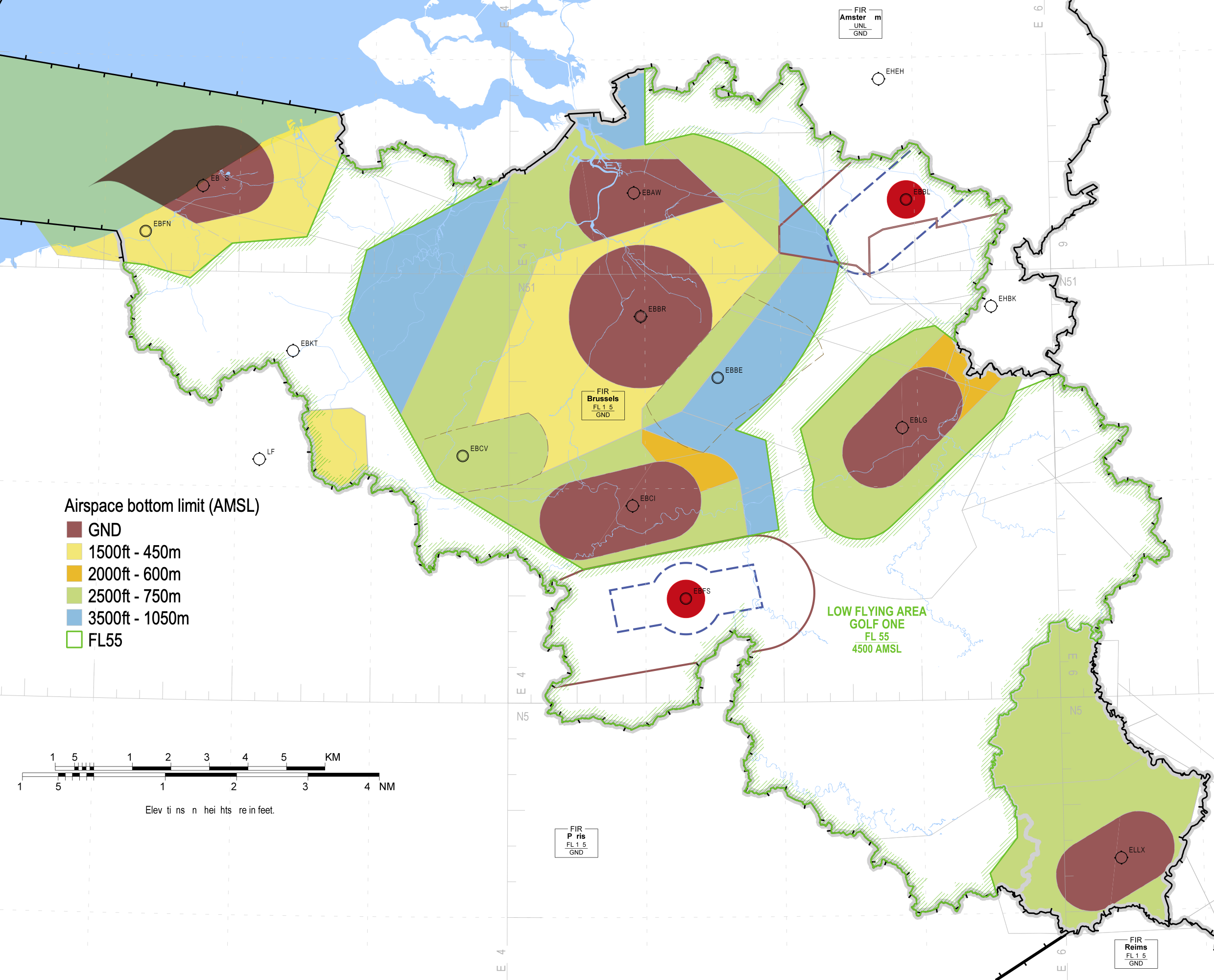
On the map below, you can see the situation with military CTRs and TMAs deactivated and LFA G 1 activated. Check activation of EBBL and EBFS during weekends. P, R, D zones not depicted on the map below. Local gliding zones not depicted on the map. Always check your NOTAMs. The only official source for aeronautical information is the AIP, so use the map below at own risk!
LFA G 2
LFA G 2 is divided in 3 sectors: West, North and South, and opens up the airspace till FL75. These sectors are shown on the map below. The activation has to be requested by the 'Liga' and the active sectors will be published on the website. These 3 sectors can be activated separately from each other. So it is possible that LFA G 2 South is active, but not West and North.

LFA G 3
This LFA G sector is a local fly-out sectors for the clubs of Verviers and will not be discussed here. More information can be found in the AIP ENR 5.5-2.
LFA G 5
LFA G 5 is split up in 2 parts, West and East. LFA G 5 opens te airspace up to FL95. The activation is published on the website.

Altimeter settings
You might have noticed the upper limit of the LFA G sectors are published as FL (Flight Levels). Since it is practically impossible for a glider pilot to change his altimeter setting from QNH to 1013.25 and back, a conversion of the upper limits to the corresponding QNH altitude is made every morning.
On the website, you will see, together with the activation of a sector, the corresponding altitude (in meters) of the upper limits. Do not forget to substract the height of your starting point if you are flying on a QFE altimeter setting.
But remember: this is not a legal way of working. Normally, you should set your altimeter to the 1013.25 hPa setting when flying above 4500 ft MSL.
The table below shows the altitude (in meters) of the flight levels 55 - 95 with different QNH values.
|
FL95 |
2680m |
2730m |
2770m |
2820m |
2860m |
2890m |
2910m |
2960m |
3000m |
3050m |
3090m |
3140m |
|
FL85 |
2380m |
2420m |
2470m |
2510m |
2560m |
2590m |
2600m |
2650m |
2700m |
2740m |
2790m |
2830m |
|
FL75 |
2070m |
2120m |
2160m |
2210m |
2250m |
2280m |
2300m |
2350m |
2390m |
2440m |
2480m |
2530m |
|
FL65 |
1770m |
1810m |
1860m |
1900m |
1950m |
1980m |
2000m |
2040m |
2090m |
2130m |
2180m |
2220m |
|
FL55 |
1460m |
1510m |
1550m |
1600m |
1640m |
1670m |
1690m |
1740m |
1780m |
1830m |
1870m |
1920m |
|
QNH |
990 |
995 |
1000 |
1005 |
1010 |
1013 |
1015 |
1020 |
1025 |
1030 |
1035 |
1040 |
All altitudes below 4500 ft can be converted to meters as follows:
|
Altitude in feet |
2000 |
2500 |
3000 |
3500 |
4000 |
4500 |
|
Altitude in meters |
610 |
760 |
910 |
1060 |
1210 |
1370 |
Airspace files for Belgium can be found here: Luchtruimbestanden. The WE files contain the airspace during weekends, the WK file can be used on weekdays.